Cala Llebeig is a small, secluded cove located between the municipalities of El Poble Nou de Benitatxell and Teulada-Moraira, on one of the most rugged and best-preserved stretches of the Marina Alta coastline.
Surrounded by cliffs and with no road access, it preserves a landscape where nature, the sea and traditional ways of life remain closely intertwined. Its isolation and the old structures beside the shore make reaching Llebeig feel like a journey into the past of the Mediterranean coastline.
A cove between ravines and cliffs
The cove lies at the mouth of the Barranc de la Viuda ravine, whose channel reaches the Mediterranean between the great rocky walls of the coast.
Its shoreline consists mainly of rock, gravel and pebbles, while the surrounding cliffs reinforce its secluded and natural character.
At one end of the cove lies Punta de l’Alderà, at the foot of Morro del Bou, one of the great rocky promontories that characterise this section of the coastline.
Old shelters beside the sea
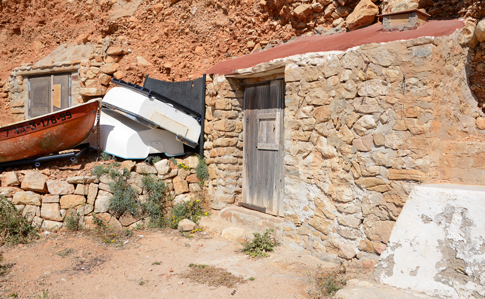
One of the most distinctive features of Cala Llebeig is its collection of old huts, caves and shelters built beside the shore and into the nearby cliffs.
These simple structures made use of natural cavities in the rock and were completed with walls, many of them built using the traditional dry-stone technique. For generations, they were used mainly by fishermen and farmers, providing places to shelter, rest or store their equipment.
Around the cove, dry-stone walls, agricultural terraces and other traces of the former farming landscape can still be recognised, bearing witness to the effort required to cultivate even the small areas of land available among the cliffs.
You can discover more about these structures in the section dedicated to the Coastal Caves.
Stories of fishermen and smugglers
The difficult accessibility of this stretch of coast made Llebeig closely associated with the lives of fishermen and farmers, but also with stories of smuggling.
The configuration of the cliffs, small coves and opportunities to hide among caves and shelters meant that some of these places were used while waiting for the arrival of llaüts and other vessels carrying goods such as tobacco or textiles.
These stories form part of Benitatxell’s popular memory and contribute to the distinctive character of Cala Llebeig, where natural landscape and ethnographic heritage are difficult to separate.
A protected natural area
Cala Llebeig forms part of the Penya-segats de la Marina, a protected area included in the Natura 2000 Network as both a Special Area of Conservation (SAC) and a Special Protection Area for Birds (SPA).
The great cliffs support plant communities adapted to extreme conditions of wind, salinity and limited soil. This area is also home to the Cala de Llebeig flora micro-reserve, created to protect some of the most valuable plant communities along this coastline.
The protected landscape continues beneath the Mediterranean, with rocky seabeds and marine ecosystems of considerable ecological value.
How to get there
Cala Llebeig has no road access. It can only be reached on foot or by sea.
From El Poble Nou de Benitatxell, the most characteristic approach is along the Ruta dels Penya-segats – Moraig-Llebeig. The trail starts at Cala del Moraig and follows the cliffs for approximately 2 kilometres before reaching Llebeig.
This route forms part of the SL-CV 50, which continues from the cove through the Barranc de la Viuda towards the municipality of Teulada-Moraira.
The cove can also be reached from inland Benitatxell via the Camí de la Serp – Puig de la Llorença – Cala Llebeig Route, a longer itinerary passing along old paths, agricultural terraces and several elements of rural heritage before descending to the coast.
Characteristics
Type: natural cove with rock, gravel and pebbles
Setting: cliffs and protected natural area
Beach services: no services
Access: exclusively on foot or by sea
Trail: SL-CV 50 – Ruta dels Penya-segats
Heritage: traditional huts, caves, shelters and old agricultural terraces
Highlights: Barranc de la Viuda, Punta de l’Alderà and Morro del Bou
Recommendation: walking access follows rugged natural terrain. Visitors should wear suitable footwear, carry sufficient drinking water and sun protection, and check weather conditions before starting the route.
Cala Llebeig is much more than a place for swimming. Its isolation, towering cliffs and the traces left by those who once worked beside the sea make it one of the best places to understand the historic relationship between the landscape, the Mediterranean and the traditional ways of life of the Marina Alta.